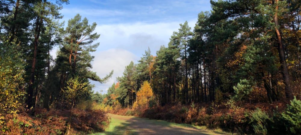
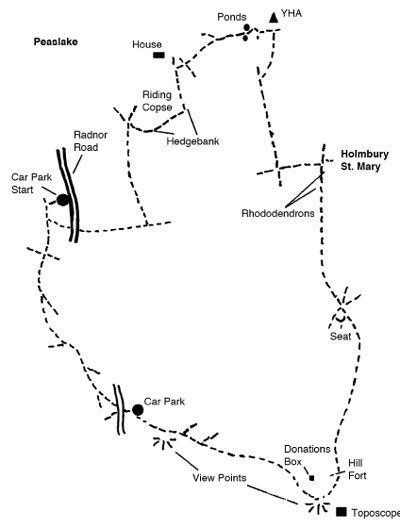
This walk starts and ends near Peaslake (car park no.1 ) and climbs to the viewpoint on Holmbury Hill.
| Map | OS Explorer 145 / 146 | |
| Carpark | TQ098431 Carpark 1 | |
| Distance | 3 miles (1 3/4 hours) | |
| Pub(s) | The Kings Head and Royal Oak, Holmbury St Mary. Hurtwood Inn and Peaslake Village Stores, Peaslake. |
Leave Peaslake on the Radnor Road the car park is about a mile along on the left hand side. Occasionally the gates to the car park are locked but there is plenty of alternative car parking along the road. The majority of the route is along woodland paths and tracks. The walk can be strenuous in places, with a steep descent at one point to reach Holmbury St Mary and a steady climb after the pubs. The scenery is stunning with the finale being Holmbury Hill Fort the second highest, after Leith Hill, of the range once known as Little Switzerland.
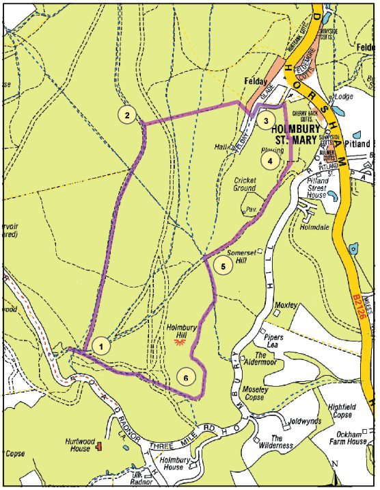
1. To start, from the car park with your back to the road, leave the car park by the main exit past the barrier. Leaving the pond on the right, continue along the broad and sandy path for 100 metres or so. Take small path branching off on left. The banks here are covered with hurts, gorse and heather, which puts up a fine show in August. Cross the next two rides, pass a large pine with a hanging branch (good seat), and just before the path enters a wood, take the countersunk path (hurts on either side) on right.
2. At the next ride, turn left. Carry on here, past electricity poles, until a small path intersects the ride. Take the right hand arm of this path, through a wooden barrier. Go down a steep wooded bank. Near the bottom, go over a wide crossing path continuing your descent, and you will soon come out onto a driveway to a house on your right. Follow the drive ahead to reach a lane in front of some pretty cottages.
The cottages are part of Holmbury St Mary which, despite its ancient appearance, is essentially a Victorian village. The village church, which you meet further on, was built in 1873 and was designed by GE Street who lived at Holmbury, whose most famous work is the London Law Courts.
3. Carry on down the lane (The Glade) into Holmbury St Mary. You will come into the green and a pub – the Royal Oak (good food – walking parties and dogs on leads welcome). Continue on round the green to the right. Either walk along the road past the Holly Bush, take the right hand fork up hill and reach the Kings Head (beer garden and home cooked meals); or take the right lane up to the church. Turn left at a small parking area and tarmac lane, going up some steps, and fork left following a holly hedge to soon enter a churchyard.
Once in the church yard, fork right taking the higher path which runs along the top of the churchyard and exit the other side via a wooden gate. After this, follow a narrow path behind some houses and fork left when you meet a pair of electricity poles supporting a mini generator, to shortly meet a lane. Turn right along the lane which will soon lead you to the Kings head.
4. From the pub, take the higher lane, Holmbury Hill Road, which runs alongside the green and at the end of the green, turn right (still Holmbury Road). A few paces after, turn right onto a track, signposted to Holmbury St Mary cricket club and follow this uphill past the cricket pitch to its end at a large junction of tracks. Deer are often seen here.
5. Take and first turning on your left, a track marked by a blue GW arrow (the Greensand Way). Sometime later, fork right passing to the right of a wooden footpath post and follow a promising path and where applicable the GW arrows, to eventually reach the top of Holmbury Hill. Holmbury Hill Fort dates from the Iron Age and is one of several along the Greensand ridge. Take time to look at the Toposcope (the panoramic guide to the view), which gives further details about the fort, and other useful information. Rest for a while at the memorial to Reginald Bray (and his brother Jocelyn) who made the public access to Hurtwood possible.
6. On leaving Holmbury Hill, with one’s back to the memorial seat, take the left hand path over a little switchback (part of the iron age fortifications) and follow this path around the edge of the escarpment. There are excellent views, following extensive clearance, of Pitch Hill and the Weald. Pass pond on right, go over little gully to reach car park No, 1 our starting point.
Leave the carpark by the footpath beside the Hurtwood Control notice board and, on reaching the broad track, turn left. At the first crossing path turn left and, at the road, cross to another path, passing between concrete bollards. After crossing two forestry roads, the path goes slightly uphill and, just after the top of the rise, turn left on to a narrow path passing a holly bush. Although you are walking through plantation, the trees are not in regimented rows; the result is more attractive open woodland. After crossing two more forest roads, the path goes downhill to a junction. Note the old beech and oak trees on the bank to the right. This is a boundary bank or hedgebank1; behind the hedgebank, the wood is called Riding Copse. At this junction, turn sharp right uphill with the hedgebank on your left and at the next junction, keeping the hedgebank on your left, turn left round the end of Riding Copse.
On reaching a small clearing with two very large old trees to the left and a large house and fields visible ahead, bear right. Continue along this path and, when it goes down into a valley, follow it up the other side on a rutted2 path. The trees are mostly deciduous close to the path, especially on the left, but on the right the pines have been felled leaving occasional broadleaved (deciduous) trees.
Soon the path goes down into another shallow valley but with two ponds. Cross between the ponds and bear left uphill. At the next junction, bear left on to a path with another old hedgebank on your left and an old iron gate; shortly this path reaches a carpark. Across the carpark to the left is Holmbury St Mary Youth Hostel.
Take the small footpath behind the Hurtwood Control information panel and, on reaching the broad sandy track, turn left; then at the next broad crossing track, turn left again. The Scots pines along here have a more natural appearance because they have more space to grow into. At the T-junction, turn right on another broad track with rhododendron on either side. The village of Holmbury St Mary is down the hill to your left.
At the junction of five paths, take the one to the left of the curved seat, continuing your previous direction. At the waymark post, bear right on the Greensand Way (GW), shortly passing through a barrier and uphill. On reaching the sign for the hill fort, take the path ahead to a high point; the hill fort is to your right. Gradually views will open up revealing The Weald, the Sussex Downs and other Surrey sandstone hills. These hills, of which The Hurtwood is part, form part of the Surrey Hills Area of Outstanding Natural Beauty (AONB). The path eventually reaches the toposcope on top of Holmbury Hill which will explain the view.
Having enjoyed the views, turn away and with the hill fort information panel on your right, take the footpath (GW) near the donations box through a deep but short cutting. Follow this path, bearing left at the next three junctions, and keeping to the edge of the hill. After going through two barriers, there is another viewpoint which has been made accessible to disabled people. Leave this viewpoint by the path opposite the way you entered, crossing a deeply rutted track and going up to a carpark. Turn left through the carpark and go down to the road, then turn right and almost immediately left by three wooden posts. Bear right at the next junction and keep ahead at the next junction (waymarked). Later, ignore the waymarked path to your left, continuing ahead until reaching a wide track at a T-junction. Bear left, then keep ahead at the crossing path and shortly right to the carpark.
1 The woodland behind the bank is called Riding Copse and is mostly broadleaved woodland. These hedgebanks were used to mark boundaries and to keep stock in or out of an area. The trees would have been managed by a system called “laying” to ensure that they were stock-proof.
2 The paths become rutted by use but also by the weather. However, the depth of the rut can be an indication of the age of the path. Some of the lanes and roads in this area of Surrey are deeply rutted not by modern roadbuilders but because they are ancient trackways previously used by horses and horse-drawn carts. Over time, the wheels and hooves cut into the sand, the loose sand is washed away by rain and the rut gets deeper. Look for them on your way home, even on the A25.
Paul Collins
Trustee, Surrey Wildlife Trust
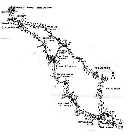
Circular Walk from Blackheath via Winterfold, Pitch Hill and Farley Green (distance 9 miles) The walk goes over heathlands and through forest. The trees give shelter in the winter and shade in the summer. It is dry walking on parts of the Greensand Way and there is only one stile. The views from Pitch Hill are unsurpassable and the garden at The Windmill pub is delightful.
Getting to the Start
Train or bus to Chilworth Station. Arriva buses from Guildford to Dorking or Cranleigh. Go over level crossing up Sampleoak Lane 3⁄4 mile. Turn left at crossroads and up to carpark at Blackheath.
The Walk
1. Leave the carpark on the right-hand (SE) path with a pine wood on your right. Keep ahead at a cross track and merge with a major track coming in from the right. Continue SE through woods, ignoring crossing paths, for 1⁄4 mile to chestnut fencing and, with fencing on the right, follow track round and past two houses on the right. At this point the track becomes a metalled lane. Follow the lane to a road junction with a fingerpost and bear left for 50 yards, then right, up a narrow path (bridleway) which goes climbing between steep banks. This climb can be very muddy, but note that a parallel path runs along the top of the left-hand bank. After the path becomes level, ignore a wide crossing path and continue ahead on a broad sandy track for 200 yards to a junction with a gate on the right. Here a bridleway bears left, leading into a carpark. There is the site of a Roman Temple at the far end of the carpark on the left. On entering the carpark turn right to the Farley Green – Shamley Green road and cross at the fingerposts.
2. Continue SE on the right-hand track. In 300 yards bear right away from fence and in another 300 yards turn left on to a main E–W track. Pass Mayor House Farm and in 200 yards start descent and continue downhill to a sunken track, which is a public byway. Cross this and turn right immediately on a footpath to walk (S), parallel to a byway, for 1⁄2 mile where you cross a dilapidated stile. Turn left through woodland to a road. Cross the road into the drive to Winterfold Cottage. Keep left at the front gate to the house and follow a hedge for 70 yards to the third waymarker on the left, opposite an old garden gate in the hedge. Here bear left, climbing through trees, and crossing a wide access track, and
continue ahead slightly right (SE) for 350 yards to a road which traverses the top of Winterfold Hill, opposite Jelley’s Hollow.
3. Cross the road and turn left up a path signposted Greensand Way (GW), parallel with the road, for 300 yards to a crossing path. Turn right and, ignoring the left-hand fork, follow the path which winds along the top of Reynards Hill (800ft). This is part of the Hurtwood Control woods, with views to the south over The Weald to the South Downs. From viewpoint with benches, the path bears left to rejoin the road by a small parking area (carpark 4 ).
4. Turn right, cross over the Shere – Cranleigh road and go up a track for 300 yards to pass a windmill on the hilltop before dropping down by a fence on your right to the Ewhurst Road. Turn right downhill for 300 yards to The Windmill pub for refreshments. There are excellent views from the pub garden to the S and SW. The distance so far is 41⁄2 miles. To enjoy the extensive views from the summit of Pitch Hill, 843 ft (4a on map), take one of the paths just below the pub, on the opposite side of the road, that climb steeply to the top. Retrace your steps.
5. From the north side of the pub go up the road for a few yards and turn left down a private road (with pub on the left at first) for 600 yards to join another road. Turn right uphill to the top and turn left at a road junction. Take the right hand of two paths (a bridleway) and continue downhill, ignoring side paths. After 500 yards the path goes through a gate and widens before being joined by a broad track from the left. Keep ahead downhill for 300 yards and pass another track coming in from the left. Continue ahead over a crossing footpath to a junction of forestry roads at the bottom and go ahead, passing a pond on the left. Cross a bridleway, through a gate and keep ahead up a slope for 1⁄4 mile to reach a metalled drive, just short of a road on the right.
6. Turn left along the drive for 300 yards past Dewdney then a further 200 yards past Lansdowne, then bear left between holly bushes down a narrow path to a bridleway at the bottom. Turn right by a stream and after 1⁄4 mile you reach a track with a house on the left. Keep ahead, ignoring a right fork, to pass a house on the right and shortly to meet a metalled lane. Here, turn left for 200 yards to a T-junction, then right into Farley Green village.
7. About 30 yards before the telephone kiosk, bear left along a sandy track on the left side of the green, then turn left along a road. At Westerlea Farm on the left, turn right on to the right hand of two tracks, both marked as a bridleway. In 600 yards, on approaching Lipscombe Cottage and its garage on the left, bear right up a sandy bridleway and through a gateway on to Blackheath. Keep left at a fork, passing a seat on the right. In 150 yards bear slightly left, taking the centre one of three tracks ahead [W] keeping a marker post on your right. Branch right at the next marker post, numbered 232, keeping this on your left, along a path somewhat obscured by forestry operations. In 100 yards, cross a wider track to go straight ahead still following path 232 – marker post lying in brush at time of writing. After a further 450 yards you join a broad track, which has been used for logging, and at the next junction keep ahead. Pass a sign on your right, “Blackheath Common”, and continue along a sandy track for 1⁄2 mile to return to the carpark at Blackheath.
Based on a walk by the late George Hyde, from Twenty-Five Favourite Walks in West Surrey & Sussex, compiled by the Godalming & Haslemere Group of the Ramblers AssociationView from Pitch Hill
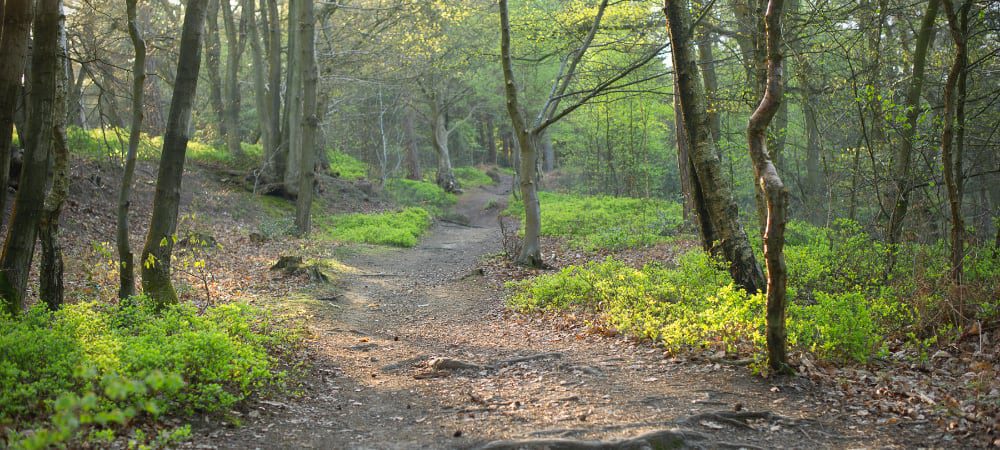
A 4 mile circular walk around The Hurtwood, a unique and beautiful world of heath and forest in the heart of the Surrey Hills Area of Outstanding Natural Beauty. The Hurtwood is a stunning mix of magical pine woods and heaths, ponds and glades, wildlife and wilderness. The walking route climbs to the summit of Holmbury Hill offering stunning views over the Weald to the South Downs, before passing through the pretty village of Holmbury St Mary and returning through the woodland.
Walk Details – Link to Alltrails
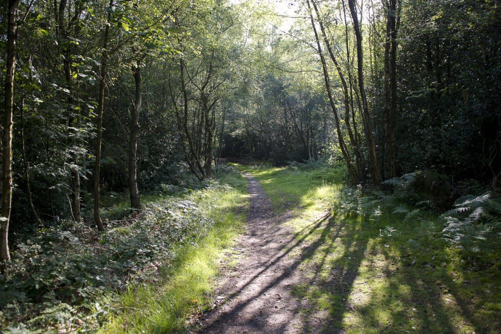
A 4.5 mile circular walk around The Hurtwood, a unique and beautiful world of heath and forest in the heart of the Surrey Hills Area of Outstanding Natural Beauty. The Hurtwood is a stunning mix of magical pine woods and heaths, ponds and glades, wildlife and wilderness. The walking route begins on Winterfold Hill, with its stunning views to the south, from where it heads north to follow a beautiful old sunken path before cutting back through the heart of Winterfold Wood.
Walk Details – Link to Alltrails
The route follows forest tracks which can be muddy after periods of wet weather. There are several climbs and descents throughout and some of the paths are narrow and uneven with tree roots. There are no stiles or gates on route, just a few staggered barriers. Dogs are welcome in the Hurtwood. You are likely to be sharing some of the paths with horse riders and mountain bikers. Allow 1.5 to 2 hours.
Walk Details – Link to Alltrails